Plethora Exploration Corp
Multi-Commodity Mineral Exploration & Discovery
category-project
Uvbergs
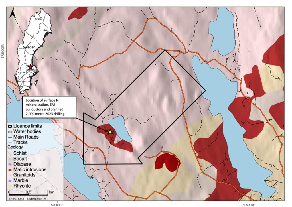
Uvbergs is an unexplored Ni-Cu-Co magmatic sulphide project located in Sweden. Recent drilling intersected ortho-magmatic Ni mineralization in 5 holes, with follow-up drilling planned to test EM conductive features. The property consists of 3 mineral exploration licences covering 9,180 hectares and can be accessed via roads throughout the year.
Overview
- Uvbergs is a Ni, Cu, Co magmatic sulphide project located in Bergslagen region of Sweden.
- Based on geological work over the past 4 years, the company has identified what it believes to be a highly prospective geological belt for Ni-sulphide discoveries, yet the belt remains mostly unexplored for this style of mineralization.
- Geophysical surveys conducted by the company revealed a near-surface conductors coincident with historical workings from the 1600’s with high-grade nickel and copper mineralization.
- A 2,000 m maiden drill program in testing the conductors in 2022 intersected orthro-magmatic Ni mineralization in 5 diamond drill holes.
- Best drill results include 8.7 m @ 0.51% NiEq* including 0.9 m @ 3.29% NiEq*
- 7,000 m of drilling will test the depth and strike extent of mineralization, as well as EM conductive features identified by Plethora Exploration in an earlier down hole geophysics surveys, which are thought to be associated with mineralization.
Geology
- In the Bergslagen district, numerous historic high-grade Ni-sulphide showings hosted in mafic-ultramafic rocks have a geochemical signature suggesting a deep mantle source and age dates of ∼1.79 Ga.
- At Uvbergs the drilling revealed a mafic-ultramafic body intruded into pyritic shist.
- The mafic-ultramafic body comprises multiple magmatic pulses, chaotic magmatic breccia textures and xenoliths of country rock, all indicators of a highly magmatic system prospective for Ni-sulphide formation.
- Unmineralized samples with <1% sulphur content often display Ni depletion relative to their expected background silicate hosted Ni contents, suggesting that Ni may have been stripped from the system and present elsewhere as Ni-sulphide mineralization.
- Mineralization observed in drill core within the mafic-ultramafic complex includes pyrrhotite, pentlandite, chalcopyrite and skutterudite.
- Multiple strong off-hole geophysical conductors, indicative of Ni-sulphide mineralization, were defined by follow-up downhole electromagnetic (EM) surveys. The identified conductive plates require drill testing in the next phase of work.
Access and Location
- The property is situated 200 km northwest of Stockholm and can be accessed via roads throughout the year.
Land Tenure
- The Property comprises 3 mineral exploration licences, together they total 9,180 hectares. The mineral exploration licences are 100% owned by Plethora Exploration.
- These mineral exploration licences are valid until 2025 and can be renewed based on sufficient exploration advancement.


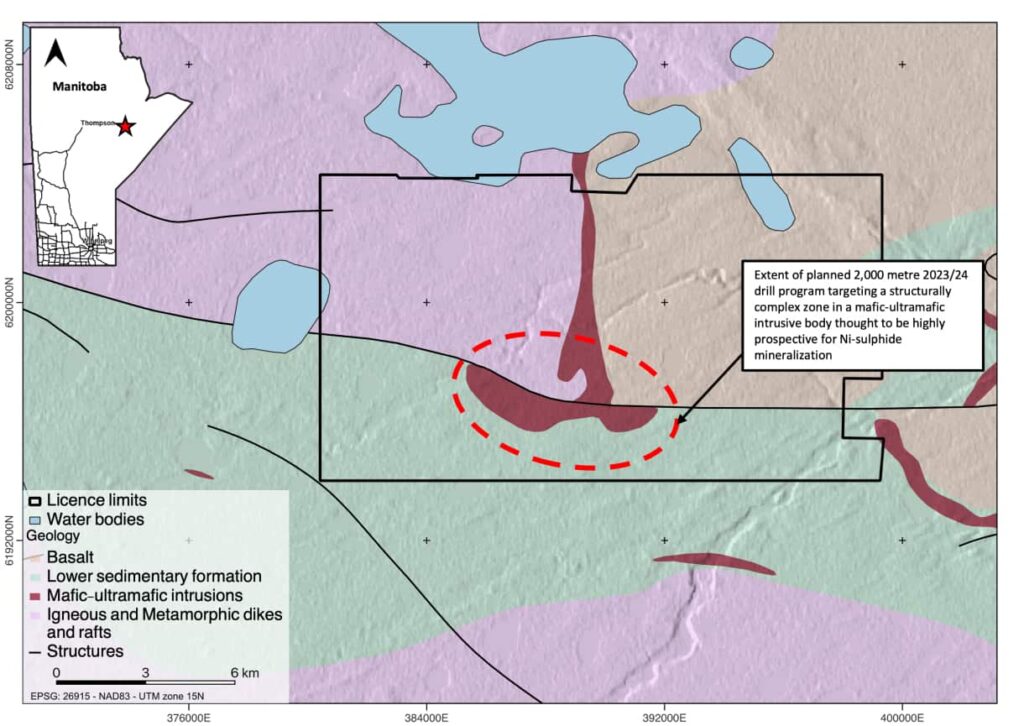
T-Bone
T-Bone is a greenfield Ni-Cu-Co, PGE magmatic sulphide project located in Northern Manitoba, Canada. The project is situated on the western extent of the Fox River Belt, a Proterozoic Greenstone Belt with significant potential due to its comparable magmatism to the Thompson and Cape Smith Nickel Belts. The T-Bone target has never been drilled, but several late-time B-Field electromagnetic anomalies have been identified through historical airborne surveys. Plethora Exploration plans to drill 2,000 meters to test the target and identify additional follow-up targets, aided by borehole EM geophysics. T-Bone is accessible year-round by helicopter, and comprises two Mineral Exploration Licences covering a total area of 19,096 hectares.
Overview
- T-Bone is a magmatic sulphide (Ni-Cu-Co, PGE) project located in Northern Manitoba, Canada
- T-Bone is located on the western extent of the Fox River Belt. The Fox River Belt is a Proterozoic Greenstone Belt which forms part of the north-western margin of the Superior Province.
- The Circum-Superior Boundary Zone is a highly prospective magmatic sulphide setting which already hosts the Thompson Nickel Belt (Thompson Mine) and Cape Smith Belt (Raglan Mine).
- Mafic and Ultramafic magmatism along the Fox River Belt and at the T-Bone target is directly comparable to magmatism along the Thompson Nickel Belt and Cape Smith Belt.
- The T-Bone target is a greenfield target, having received limited historic exploration via airborne surveys and no drilling.
- Re-processing of historic airborne geophysics have identified several late time B-Field electromagnetic anomalies.
- 2,000 metres of drilling is planned to test the T-Bone target. Borehole EM geophysics will aid in identifying additional follow-up drill targets and guide towards massive sulphide mineralization.
Geology
- T-Bone is targeting mafic – ultramafic lithologies of the lower intrusive package of the Fox River Belt.
- The lower intrusives represent the lowermost level of intrusive activity across the belt and are predominantly well differentiated in parts – peridotite base, overlying pyroxene rich layer and upper gabbronorite, elsewhere the comprise a zoned peridotite core and pyroxene margin.
- LREE sampling at lower intrusives across the belt suggests an enrichment likely due to interaction with country rock.
Access and Location
- T-Bone is situated approximately 50 kms southeast of the town of Gillam and 50 kms east of Ilford, in Northern Manitoba, Canada.
- Access to the property can be made year-round by helicopter with existing snow mobile trails scattered across the property used by hunters.
Land Tenure
- The Property comprises 2 Mineral Exploration Licences (MELs) covering a combined total land area of 19,096 hectares. A 5,153 Ha claim covering the main target zone is subject to an option agreement with Kenorland Minerals Inc. Plethora Exploration has the right to acquire 100%. The remaining claims are 100% owned by Plethora Exploration.
- The MELs are valid for a period of 5 years from issue and can be renewed for a further 5 years.
Oil Patch
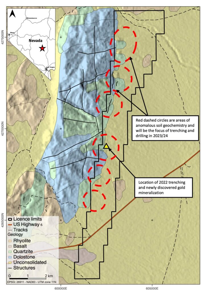
Oil Patch is a promising Carlin-style gold project in Nevada’s Nye County, easily accessible and with good infrastructure. Field work by Plethora Exploration has identified high-grade gold mineralization, with drill and trenching programs planned to test the extent of mineralization and lithological and structural traps. The mineralization occurs at the silicified boundary between the upper Devonian Guillemette Formation and Tertiary volcanics, with significant mineralization in gold-bearing karst breccias. The project is located in the historic Railroad Valley oil and gas district and comprises 289 contiguous mining claims covering 2,416 hectares, all 100% owned by Plethora Exploration.
Overview
- Oil Patch is a Carlin-type gold project located in Nye County, Nevada
- Easily accessible with good infrastructure and in a world-class mining jurisdiction
- Field work conducted by Plethora Exploration has demonstrated high-grade gold mineralization in the highly prospective Devils Gate rock formation. Surface trenching results included: 72.0 m @ 0.23 g/t Au and 30.0 m @ 0.30 g/t Au, including higher grade zones up to 3.7 m @ 1.43 g/t Au.
- Mineralization remains open and untested in both directions along the trenches. Geological mapping and sampling suggests the potential for an extensive Carlin-style gold system.
- Serval large, high-priority, multi-element soil anomalies remain untested.
- 6,000 metres of drilling and further trenching is planned to test the thickness, strike, and depth extent of the gold mineralization discovered in the 2022 trenches, as well as testing lithological and structural traps for higher grade zones.
Geology
- The mineralisation at Oil Patch is located at the silicified boundary between the upper Devonian Guillemette Formation (Devil’s Gate Limestone) and the overlying unconformable Tertiary volcanics.
- Silicification occurs as decalcification of the upper Devil’s Gate limestone and formation of jasperoids as well as moderate to strong silica flooding found primarily in the overlying volcanic units.
- Trenching in 2022 targeted the soil anomaly and the angular unconformity. The trenching indicates that gold-bearing karst breccias adjacent to the angular unconformity host significant mineralisation and provide a large tonnage gold target. It also confirms the soil anomaly is representative, and a good indicator of buried mineralization.
Access and Location
- Located in Railroad Valley – a historic oil and gas district in Nevada with existing infrastructure.
- Oil Patch is accessible by car along Route 6, which heads SW from Ely and is 120 km SW of Ely and 150km from Tonopah. Access to the licence area is via an off-road track and the full extent of Oil Patch is accessible by 4WD vehicle or ATV.
Land Tenure
- Oil Patch comprises 289 contiguous mining claims all within BLM ground covering a total area of 2,416 hectares. The claims are valid until November 1st, 2023, and can be renewed on a yearly basis. Claims are 100% owned by Plethora Exploration.
Mt Tobin
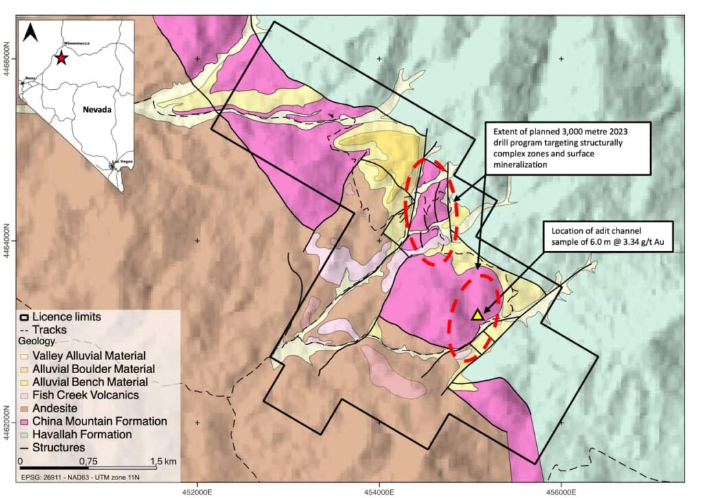
Mt Tobin is a low sulphidation epithermal gold project in Nevada with rock chip samples of up to 9.83 g/t Au. Multiple anomalous zones of pathfinder elements and alteration associated with Low Sulphidation Gold systems make compelling drill targets. Plethora Exploration plans to test the zones with 3,000 metres of drilling. The Property comprises 121 unpatented mining claims all within BLM land covering a total area of 1,012 hectares and are 100% owned by Plethora Exploration.
Overview
- Mt Tobin is a low sulphidation epithermal gold project located in Pershing County, Nevada.
- Easily accessible with good infrastructure and in a world-class mining jurisdiction.
- Field work conducted by Plethora Exploration yielded rock chip samples of up to 9.83 g/t Au and two continuous chip channel samples of 6.0 m @ 3.34 g/t Au and 1.0 m @ 8.68 g/t Au
- A soil survey and geological mapping identified multiple zones of anomalous pathfinder elements and alteration associated with Low Sulphidation Gold systems. These anomalous zones appear to be structurally complex and make compelling drill targets.
- 3,000 metres of drilling is planned to test the main zones of geochemical anomalism and the structurally complex zones at the Mt Tobin Low Sulphidation Epithermal Gold Project
Geology
- Historically known mercury district and was a past-producer from 1938-1942 but little effort was made to link the high-level mercury occurrences to a deeper gold-rich epithermal system.
- Various high-level epithermal vein textures are observed on the property, primarily at the Rockhouse and Rockhouse West zones. High gold grades (up to 9.8 g/t Au) are associated with quartz after calcite, bladed textures.
- Gold mineralization occurs in association with open-space fill textures, such as bladed silica replacement after carbonate (i.e., evidence of boiling) and hydrothermal breccias, which suggests proximity to the palaeosurface and a low-sulfidation nature of mineralization.
- The principal structural feature is a northwest trending volcano-tectonic graben. The margin of the graben is defined by northwest trending faults that have juxtaposed the Havallah sequence against China Mountain Formation. Faults and fractures in the China Mountain Formation are numerous and some have provided the conduits for Tertiary hydrothermal fluids.
Access and Location
- Mt Tobin is situated approximately 70 km south of Winnemucca in the Central Tobin Range and lies at the northern end of the Tobin mining district within the Tobin Range.
- A county-maintained dirt road in Golcanda Canyon provides access to the western part of the study area. An improved dirt road through Bushee Creek Canyon provides access to the northern part of the district.
- All accessible via truck and ATV
Land Tenure
- The Property comprises 121 unpatented mining claims all within BLM land covering a total area of 1,012 hectares. The claims are valid until September 2023, they can be renewed on a year-by-year basis. Claims are 100% owned by Plethora Exploration.
Kuså
Kuså is a Ni, Cu, Co magmatic sulphide project in Sweden’s Bergslagen region. Plethora Exploration identified strong conductive features coincident with surface sampling and plans to test the EM conductive features with 2,000 m of drilling. The entire belt has only seen ∽10,000 m of modern exploration drilling for Ni-sulphide, 2,000 m of which was at Uvbergs by Plethora Exploration and the remaining 8,000 at a project 50 km east. The Property comprises 2 mineral exploration licences, together they total 492 hectares and 100% owned by Plethora Exploration Corp.
Overview
- Kuså is a Ni, Cu, Co magmatic sulphide project located in Bergslagen region of Sweden.
- Based on geological work over the past 4 years, the company has identified what it believes to be a highly prospective geological belt for Ni-sulphide discoveries, yet the belt remains mostly unexplored for this style of mineralization.
- Surface sampling and geological mapping by Plethora Exploration identified economic grades in rock chips and waste piles with grades up to 1.98% Ni, 3.00% Cu, 0.18% Co, 0.5g/t 3PGE
- Follow-up airborne and ground EM geophysical surveys identified strong conductive features coincident with surface sampling, historic mine workings, and an extensive body of favorable host rock.
- 2,000 m of drilling is planned to test the previously identified EM conductive features and the depth and strike extend of mineralization observed at surface.
Geology
- In the Bergslagen district, numerous historic high-grade Ni-sulphide showings hosted in mafic-ultramafic rocks have a geochemical signature suggesting a deep mantle source and age dates of ∼1.79 Ga.
- The entire belt has only seen ∽10,000 m of modern exploration drilling for Ni-sulphide, 2,000 m of which was at Uvbergs by Plethora Exploration and the remaining 8,000 at a project 50 km east. Both projects identified significant magmatic Ni-sulphide mineralization
- A mafic-ultramafic body intruded into pyritic shist and granites is the host to the Kuså Ni-sulphide mineralization.
- The mafic-ultramafic body comprises multiple magmatic pulses, chaotic magmatic breccia textures and xenoliths of country rock, all indicators of a highly magmatic system prospective for Ni-sulphide formation.
Access and Location
- The property is situated 230 km northwest of Stockholm and can be accessed via roads throughout the year.
Land Tenure
- The Property comprises 2 mineral exploration licences, together they total 492 hectares and 100% owned by Plethora Exploration Corp.
- These mineral exploration licences are valid until 2025 and can be renewed based on sufficient exploration advancement.
Frostmoen
Frostmoen in Nordland County, Norway is a sediment-hosted Cu, Co, Ni project with significant mineralization in dolostone breccia. A 6.5km soil anomaly indicates a large mineral system, and 6,000m of drilling is planned. The Property is accessible from a paved road and comprises of 5 Rights of Examination owned by Plethora Exploration.
Overview
- Frostmoen is a sediment hosted Cu, Co, Ni project located in Nordland County, Norway.
- Plethora Exploration identified surface mineralization in trenching, and a historic underground adit
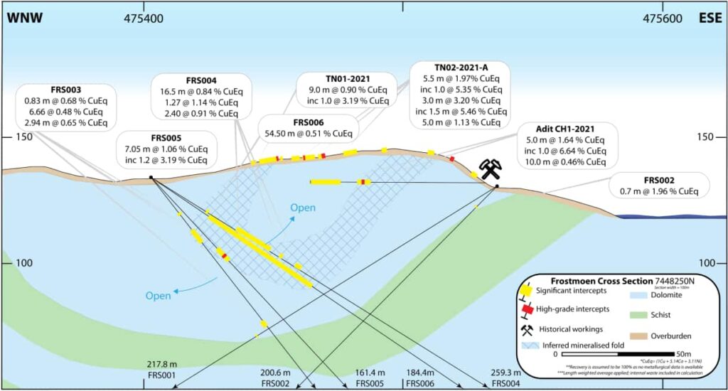
- A maiden 1,200 m drill program conducted in 2022 by the company revealed significant Cu, Co, & Ni mineralization associated with a dolostone breccia.
- Best drill results include 54.5 meters @ 0.51% CuEq* and 7.1m @ 1.06% CuEq*.
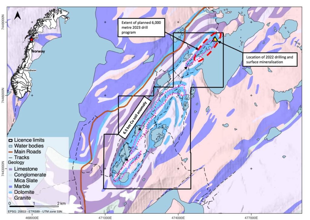
- A 6.5 km long multi-element soil anomaly coincident and along strike from known mineralization suggest the potential for a strike extensive large-scale mineral system.
- 6,000 m of drilling is planned to test the true thickness and strike extend of mineralization at the Frostmoen Cu project.
Geology
- The dolomite-dominated marble unit with associated meta-siliciclastic rocks underwent intense ductile deformation and metamorphism during the Caledonian orogeny. Mineralization is believed to be pre-Caledonian.
- The host dolostones are primarily composed of Ca-Mg carbonate with minor bands of mica.
- Brecciation can be observed within the dolostone unit and is monomictic in nature.
- Dolostone breccia is formed by an event of a collapse creating a jumbled mixture of angular fragments cemented together.
- Anhydrite dissolution is inferred to have taken place, creating increased permeability in the dolostone breccia for mineralizing fluids.
- The copper-cobalt-nickel mineralization is confined to the metamorphosed and brecciated dolostone.
Access and Location
- The Property is situated in Nordland County, Norway, approximately 15 km south of the town of Bodø in the Salten region.
- The Property is accessible from the FV17 paved road 20 km south of Bodø, followed by a 30-minute hike along a footpath or by boat from the northern docking area on Valnesvatnet lake.
Land Tenure
- The Property is comprised of 5 Rights of Examination. The Rights of Examinations are currently valid until 2027. The Rights of Examination are 100% owned by Plethora Exploration.
- The combined areal extent of the Property is 1,784 hectares.
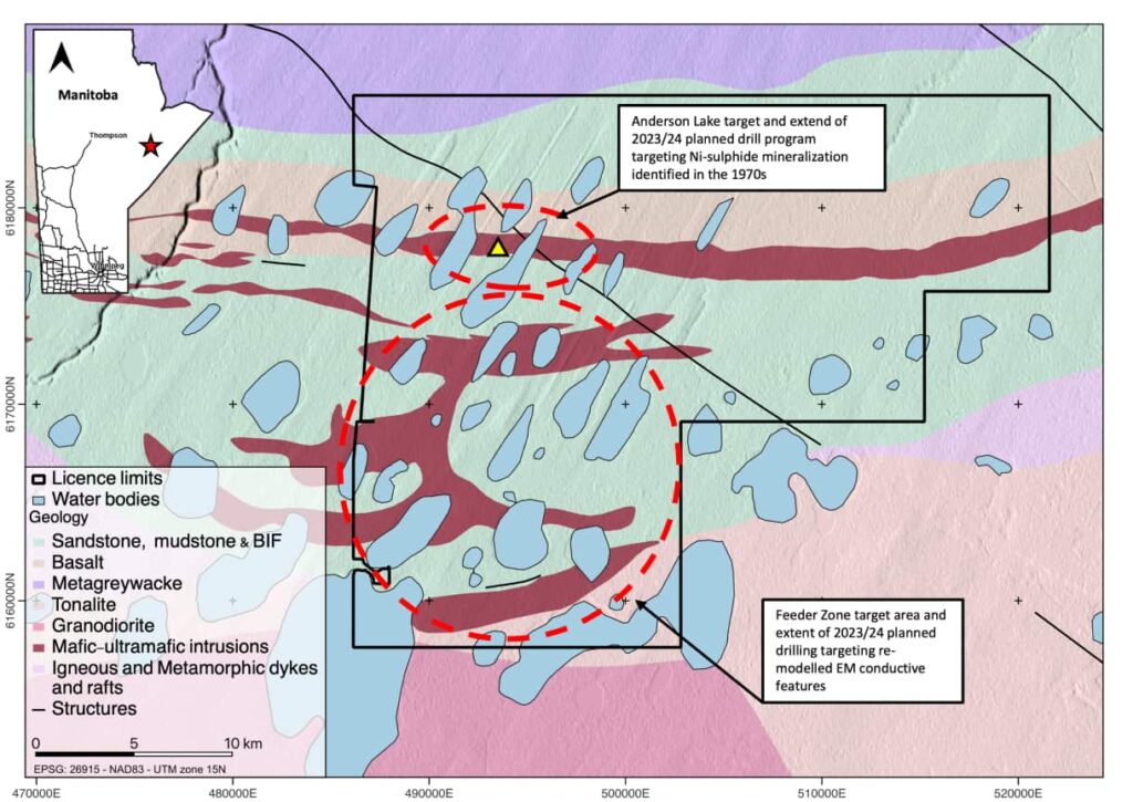
Feeder Zone and Anderson Lake
Feeder Zone and Anderson Lake are Ni-Cu-Co and PGE projects located in Northern Manitoba, Canada within the highly prospective magmatic sulphide setting of the Fox River Belt. Limited historic drilling has been undertaken with promising results, and Plethora Exploration plans to conduct approximately 3,000 metres of drilling to test EM targets identified through remodelling of historic data and historic Ni intercepts. Access to the property can be made year-round by helicopter, and the Property comprises 3 Mineral Exploration Licences covering a total land area of 57,5967 hectares.
Overview
- Feeder Zone and Anderson Lake are magmatic sulphide (Ni-Cu-Co, PGE) projects located in Northern Manitoba, Canada
- Located in within the Fox River Belt. The Fox River Belt is a Proterozoic Greenstone Belt which forms part of the north-western margin of the Superior Province.
- The Circum-Superior Boundary Zone is a highly prospective magmatic sulphide setting which already hosts the Thompson Nickel Belt (Thompson Mine) and Cape Smith Belt (Raglan Mine).
- Mafic and Ultramafic magmatism along the Fox River Belt and at the Anderson Lake target is directly comparable to magmatism along the Thompson Nickel Belt and Cape Smith Belt.
- Limited historic drilling has been undertaken across Anderson Lake by INCO 1971-72 and BP / Selco in 1987-88. The BP / Selco drilling reported 1.45 % Ni over 2.0 m in hole 87-3 and 0.51 % Ni over 2.0 m in 87-1A. Drilling by INCO suggests 44.0 m of discontinuous pyrhottite and chalcopyrite.
- Remodelling by Plethora Exploration of historic geophysical surveys at identified strong late-time airborne and ground EM conductors; EM conductors are often directly correlated to massive sulphide mineralization and represent high priority drill targets
- Approximately 3,000 metres of drilling is planned to test EM targets identified in re-modelling of historic data and historic Ni intercepts. Follow-up Borehole EM geophysics will help to identify additional drill targets.
Geology
- Anderson Lake is sits within the Fox River sill which is comprised of repeated cyclic units of primitive large igneous province derived magmatism.
- Feeder Zone is targeting mafic – ultramafic lithologies of the lower intrusive package of the Fox River Belt.
- The lower intrusives represent the lowermost level of intrusive activity across the belt and are predominantly well differentiated in parts – peridotite base, overlying pyroxene rich layer and upper gabbronorite, elsewhere they comprise a zoned peridotite core and pyroxene margin.
Access and Location
- The project is situated approximately 110 kms southeast of the town of Gillam and 70 kms west of Shamattawa, in Northern Manitoba, Canada.
- Access to the property can be made year-round by helicopter. A winter road between Gillam and Shamattawa runs 40 km north of the project.
Land Tenure
- The Property comprises 3 Mineral Exploration Licences covering a total land area of 57,5967 hectares. A 5,304 Ha claim covering two drill targets is subject to an option agreement with Kenorland Minerals Inc. Plethora Exploration has the right to acquire 100%. The remaining claims are 100% owned by Plethora Exploration.
- The MELs are valid for a period of 5 years from issue and can be renewed for a further 5 years.
